Artificial Intelligence (AI) is a key capability enabling a new generation of warfighters and intelligence analysts. Whether AI should be used in the modern battlefield is no longer being discussed. Instead, commands are already thinking about how fast AI can be deployed, how securely and for which missions it can be deployed moving forward. Earthcube is at the center of this trend. This innovative startup is conceiving the algorithmic warfare tools of the future. I recently discussed their capability and vision with their CEO, Arnaud Guérin.
Earthcube History and Solutions
Q: How did Earthcube come to be?
Renaud (my partner) and I were working in complementary fields. I was in charge of monitoring solutions at Areva, and Renaud was working in earth observation at Airbus. When sharing our professional experiences, we understood that remote sensing data could be very useful to solve lots of monitoring applications, but were heavily undervalued—mainly due to the fact that images were processed manually. AI solutions existed, but were mainly techno-push horizontal approaches, not always fitting clients’ needs. So in 2016, we decided to leave our jobs and start Earthcube in order to enable global monitoring for very specific applications, and to bring to market AI integrated products with real business value.
Very early in the project, we realized that the Defense and Intelligence sector was surprisingly very poorly served in terms of automating the monitoring process for large areas, so we decided to go forward with targeting this market and deliver end-to-end products for these users. With the emergence of new sensors—whether they are satellite, UAV or plane—we have seen here a great opportunity to close the gap between AI in the lab and Activity Based Intelligence (ABI) in the field.
Q: Real experts in AI are hard to find, though everybody seems to highlight and advertise “AI” tools. What makes the Earthcube team special and different from other AI companies?
So far, there are only a few AI startups that deal with remote sensing data. Most of the AI startups are developing B2C, HR or marketing applications. So we are pretty unique in our field, which is illustrated by our team’s unique skills and experiences.
We attract very innovative, experienced and autonomous team members, who have both a passion for AI and a strong interest in aerospace and defense technology. I think that a third of the team has a pilot’s license and another third is serving in the reserves. People here come and stay because they have the opportunity to work on mission-focused projects. Every entrepreneur says he or she wants to make a difference, but I tend to think that at Earthcube, we are actually doing it. Our projects, data and product are actually impacting people on the field. We are trying to make the world a little safer for people who serve, and a little less scary for people who live in it.
We are also different because we are truly doing real deep-tech AI. When you look behind the hype, most AI startups do not go deep in the technology. Tweaking an already trained model is often enough for most applications. In fact, this approach is great, because AI is hard—very hard—and if you can bring great value with simple technology, it has the most impact on the mission.
But when you deal with remote sensing data, it is another story. First, because remote sensing data are scarce, expensive, heavy and complex (and sometimes confidential), and also because our clients need very high performance. For national security use cases, nobody settles on an 80% detection rate; 90 or 95% is a requirement to be relevant. Consequently, we developed very unique proprietary technology. We developed our own model, network, framework and process by focusing on R&D to push the boundary of the field. This allows us to attract very talented people—world-class mathematicians and engineers—who want to work at the cutting edge of technology.
Q: What solutions are you currently taking to market?
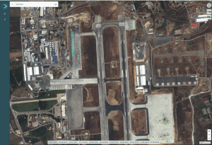
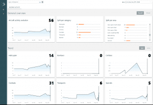
Today we are proposing a number of different services to the national security and defense market, but one of our flagship products is the S-Cube (for “Strategic Site Surveillance”) GEOINT platform. It comes as a SaaS or on-premise software providing intelligence as a service. This platform allows analysts who are doing recurrent strategic monitoring of large areas to prioritize their work and leverage the latest commercial and open source data. We combine military geography and several levels of AI to enable automatic alerting, tipping and cueing—all integrated within the analyst workflow.
The product works in two stages:
- First, every time an image is acquired on a site, we process it to automatically detect military activity by identifying specific objects on satellite images (vehicle, aircraft, etc.) against NATO STANAG 3596 ontology. All activities are then stored in a MarkLogic® database as geospatial objects with several layers of attributes.
- Then we look at different patterns of life and spatiotemporal signals in identified activities. If specific or unusual events are detected, we trigger an alert. This is done by querying the MarkLogic database and performing supervised or unsupervised analysis. For example, if we detect an increase of logistic activity in a submarine docking area of a harbor, we can then inform the analyst that there is a high probability of departure of the submarine in the next days.
With this product, analysts can focus on high-value tasks and leverage all images they have access to without the need to look at each of them. The product is modular and can thus be adapted to already existing infrastructures or specific client needs.
We also provide an off-the-shelf AI solution for airborne imagery, for example, for pipeline monitoring, military vehicle identification or anomaly detection. And, we have several civilian GEOINT projects for security and environment application.


Why Earthcube Relies on MarkLogic
Q: In large ABI and Algorithmic Warfare solutions deployment, what qualities are you looking for in a database?
We are looking for several things in our database:
- The first is security. We are working with sensitive clients and sensitive data. We cannot afford to use an unsecured solution. The native credential management and advanced security in MarkLogic is a huge saving of time and worries as we build mission-critical systems.
- Performance and versatility are critical for us. We are building very large databases of millions of different objects and performing thousands of analysis and query calculations when images are acquired. Consequently, MarkLogic’s ability to perform real-time analysis quickly and at scale is a very strong differentiation in the market.
- Flexibility is also a strong asset of the MarkLogic database for our application. All of the system’s characteristics and states are stored in MarkLogic. This is where we input our standard methodology—our object classification—where we initialize each site with several sub-areas of interest or predefine standard alerts. However, the methodology, objects or geography evolve. New buildings are constructed, new materials appear on the battlefield and new categories are added to STANAG standards to cope with the evolution of doctrine and warfare. With MarkLogic’s ability to hierarchize data with ad hoc schema, we are not bound to a specific data model. The user can adapt, regroup or create new levels of information without the need to redefine the whole system. This is also a key aspect for us and our clients, as our systems are deployed in sensitive contexts, so they need to be flexible and easily configurable without Earthcube intervention.
For More Information
- Visit the Earthcube website.
- Explore the capabilities of the MarkLogic database.
- Learn about MarkLogic solutions for National Security.


